


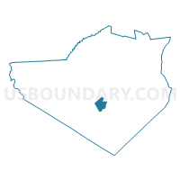
Voting District 020003, Orange County, New York
About
Outline

Summary
| Unique Area Identifier | 633600 |
| Name | Voting District 020003 |
| County | Orange County |
| State | New York |
| Area (square miles) | 5.94 |
| Land Area (square miles) | 5.90 |
| Water Area (square miles) | 0.04 |
| % of Land Area | 99.34 |
| % of Water Area | 0.66 |
| Latitude of the Internal Point | 41.33138720 |
| Longtitude of the Internal Point | -74.30904950 |
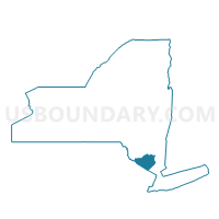
Maps

Graphs
Select a template below for downloading or customizing gragh for Voting District 020003, Orange County, New York


Neighbors
Neighoring Voting District (by Name) Neighboring Voting District on the Map
- Voting District 020005 020008, Orange County, NY
- Voting District 020007, Orange County, NY
- Voting District 020009, Orange County, NY
- Voting District 020012, Orange County, NY
- Voting District 060006, Orange County, NY
- Voting District 060011, Orange County, NY
- Voting District 210006 210029, Orange County, NY
- Voting District 210012, Orange County, NY
Top 10 Neighboring County Subdivision (by Population) Neighboring County Subdivision on the Map
- Warwick town, Orange County, NY (32,065)
- Goshen town, Orange County, NY (13,687)
- Chester town, Orange County, NY (11,981)
Top 10 Neighboring Place (by Population) Neighboring Place on the Map
Top 10 Neighboring Unified School District (by Population) Neighboring Unified School District on the Map
- Warwick Valley Central School District, NY (23,647)
- Goshen Central School District, NY (18,063)
- Chester Union Free School District, NY (6,448)
- Florida Union Free School District, NY (4,991)
Top 10 Neighboring State Legislative District Lower Chamber (by Population) Neighboring State Legislative District Lower Chamber on the Map
Top 10 Neighboring State Legislative District Upper Chamber (by Population) Neighboring State Legislative District Upper Chamber on the Map
Top 10 Neighboring 111th Congressional District (by Population) Neighboring 111th Congressional District on the Map
Top 10 Neighboring Census Tract (by Population) Neighboring Census Tract on the Map
- Census Tract 143.02, Orange County, NY (6,958)
- Census Tract 119, Orange County, NY (6,228)
- Census Tract 143.01, Orange County, NY (5,023)
- Census Tract 144, Orange County, NY (4,601)
- Census Tract 147, Orange County, NY (4,465)
- Census Tract 121, Orange County, NY (3,893)